Your cart is currently empty!
The “One-Stop-Shop Drone” for Surveying. Check out the all new WingtraRAY.
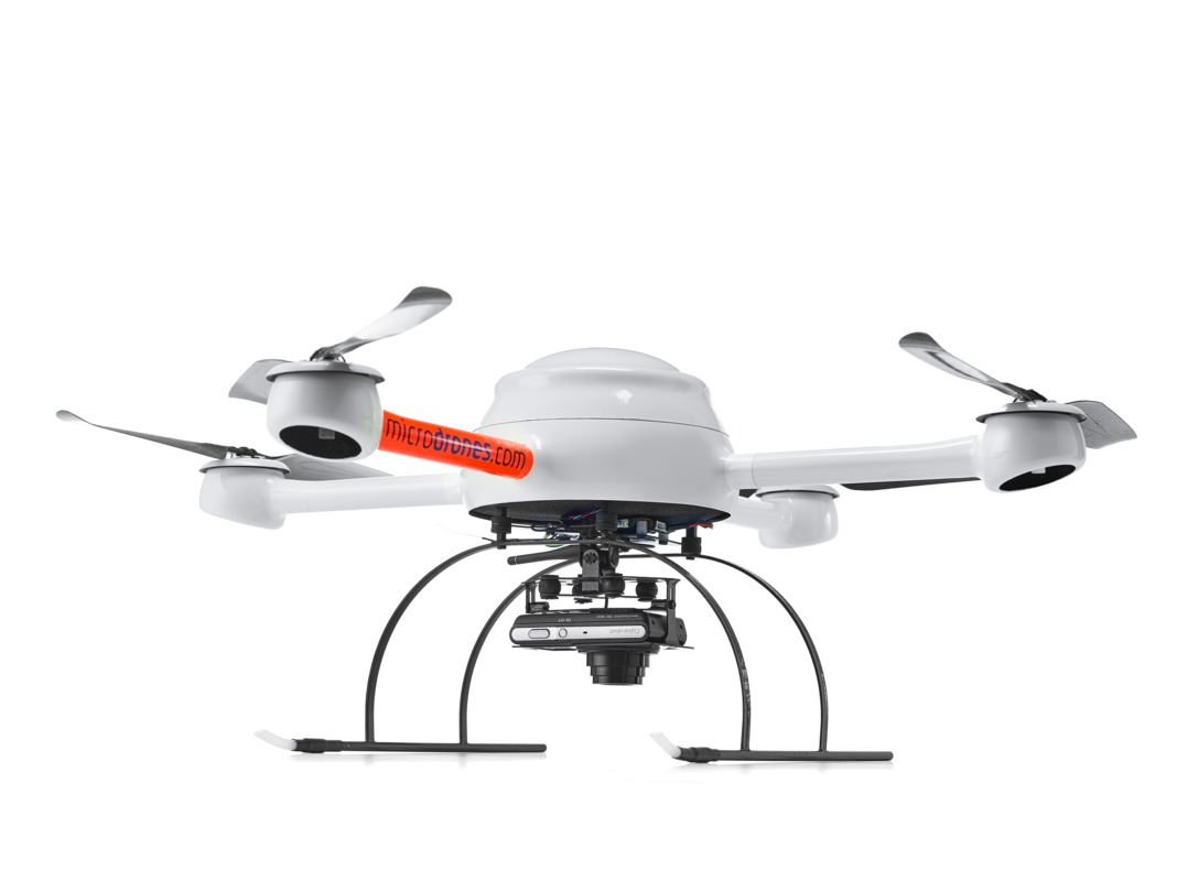
DEMO MICRODRONES MDMAPPER 1000
$7,500.00
The Microdrones mdMapper system is a professional solution for aerial surveying and mapping that relies on traditional photogrammetric workflows. It is a complete, integrated package designed to be an accessible entry point for professionals who need high-quality data.
Description
This is a demonstration unit.
Core Components and Functionality
- UAV Platform: The system is built around a robust, multi-rotor drone platform like the md4-1000, known for its stability and resilience in various weather conditions.1
- Payload: It is equipped with a high-resolution camera, such as a Sony a6300 or RX1R II, specifically integrated for mapping.2
- Georeferencing: Instead of DG, these models use Post-Processed Kinematic (PPK) technology.3 This means the system records precise GPS and inertial data during the flight, but this data is not used for real-time positioning. To achieve survey-grade accuracy, the workflow relies on a handful of Ground Control Points (GCPs).
Workflow: The workflow is designed to be straightforward and efficient, following three main steps:
Plan: Using the mdCockpit mobile app on an Android tablet, users can easily draw a polygon over the area to be mapped. The software automatically generates a flight grid and allows for the easy setting of parameters like flight altitude, and front and lateral image overlap.
Fly: The drone flies the pre-planned mission on autopilot, while the user monitors the flight telemetry in real-time.
Process: After the flight, the data, including geotagged photos, is transferred to a computer.8 The images are then processed using specialized photogrammetry software (e.g., mdInfinity) to create high-quality deliverables such as orthomosaics, point clouds, and 3D models.
Deliverables: The final products are high-resolution, georeferenced maps and models suitable for various professional applications, including construction site monitoring, volume calculations, and topographic mapping.
The non-DG mdMapper offers a powerful and reliable way to produce professional-grade mapping data, but its accuracy and efficiency are dependent on the use of GCPs, making it a more traditional and cost-effective approach compared to the flagship DG models.
Related products
-
")
DEMO WISPR SkyScout Pro w/ Black Herelink
$7,500.00 -

DEMO Ranger Pro 1100 Package
$15,000.00 -

+mdLiDAR (Payload only)
$20,000.00 -

Microdrones mdMapper 1000 DG
$15,000.00 -

DELAIR UX11 W/ PPK INCLUDING 3G
$10,000.00
Reviews
There are no reviews yet.