Description
The Sony ILX-LR1 Camera
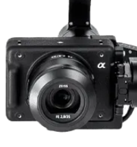
The ILX-LR1 is a professional, purpose-built camera for industrial applications. It features a full-frame 61-megapixel sensor, which provides an exceptionally high resolution of 9504 x 6336 pixels. This level of detail allows for a much lower Ground Sample Distance (GSD), meaning each pixel on the ground represents a very small area. For mapping, this high resolution enables the capture of intricate details and allows for larger areas to be surveyed in fewer images and at higher altitudes, increasing mission efficiency. The camera is also lightweight, which helps to maximize the drone’s flight time and overall payload capacity.
The Custom Gimbal
A custom gimbal is an essential part of this setup. Unlike a standard mount, a gimbal actively stabilizes the camera along its pitch, roll, and yaw axes using brushless motors. This is crucial for aerial photography because it counteracts the drone’s vibrations and movements caused by wind or flight maneuvers. The custom nature of the gimbal ensures a perfect fit for the ILX-LR1 and its specific lens, providing optimal balance and stability. This results in sharper, blur-free images that are vital for creating accurate orthomosaics, 3D models, and point clouds. The gimbal also enables the camera to be pointed straight down for nadir mapping or at an angle for oblique imaging.
The 35mm Lens
A 35mm fixed-focal-length lens is a popular choice for mapping and surveying. It provides a natural-looking perspective with a moderately wide field of view. This focal length strikes a balance between capturing a large area in each photo and minimizing the distortion that is common with wider-angle lenses. The result is a more accurate and consistent image, which simplifies the process of stitching photos together in post-processing to create a seamless final map.
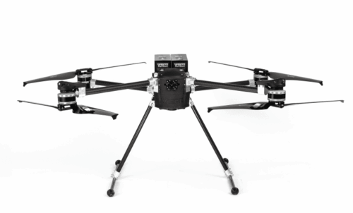
How the Setup Works on the SkyScout
When combined on the WISPR SkyScout, this payload creates a highly effective system for geospatial data collection. The drone’s RTK/PPK navigation provides precise location data for each photo, while the gimbal-stabilized camera captures high-resolution imagery. This synergy allows professionals to fly faster, cover more ground, and produce exceptionally detailed and accurate deliverables, such as orthomosaics and 3D models, with reduced need for ground control points. The result is a professional solution for surveying, asset inspection, and construction monitoring that is both efficient and delivers superior data quality.
Reviews
There are no reviews yet.