Your cart is currently empty!
Powerful Range, Elevated Precision.


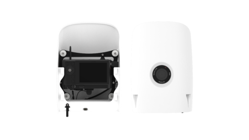
Quantum Systems F90+ Payload – Qube 240 LiDAR
$57,500.00
The Qube 240 payload is a geomatics grade LiDAR Scanner for the Trinity F90+ UAS and it endures up to 60 min of flight time with this combination. It is offered as a complete solution, all encompassed with YellowScan CloudStation Software pack, and license.
Description
A small and powerful LiDAR sensor for the Trinity F90+ UAS
The Qube 240 LiDAR sensor inherits the YellowScan Ultra Surveyor LiDAR scanner, which was first integrated into the Quantum Systems Tron UAS in 2017. Advances in miniaturization and performance improvements have increased the range and accuracy while providing a significantly smaller form factor. This is impressively reflected in the cost reduction of over 50% for the overall system.
A geomatics grade LiDAR solution from a single source
The Qube 240 LiDAR provides essential information for surveying and mapping by generating an accurate 3D image of the process environment through 240,000 distance measurements per second.
Outstanding absolute accuracy is achieved with the help of the integrated Applanix APX15 INS. One can speak of a geodetic accuracy that was previously only achievable with LiDAR Systems of the upper price segment. Additional benifits include easy handling, user-friendly integration, as well as fast and easy processing of raw data.
YellowScan CloudStation software is included which is enclosed in an adapted variant with a 1-year subscription license.
Features
-
- Geomatics Grade LiDAR
- Class 1 (Eye Safe)
- Wave length: 905 nm
- Maximum altitude: 140 m AGL
- Precision: 1.8-2.5 cm
- Accuracy: < 3 cm
- Scanner field of view: 70°
- 240,000 shots per second
- Point density @100m: 50-100 points/m2
- Multi-echo technology: up to 3 echoes per shot
- Applanix POSPacTM UAV, GNSS, and INS software for PPK
- Qube 240 data processing software to generate survey-grade LAS Files. Efficient, high-resolution, and perfectly aligned elevations surveyed without compromise
- Automatic classification of ground points
Use Cases
- Power Line Surveying and Mapping
- Forestry & Agricultural Surveying and Mapping
- Mobile Surveying and Mapping Large areas that need to be surveyed with LiDAR View
Additional information
| Weight | 5 lbs |
|---|
Related products
-
DJI Mavic 3 Thermal
$5,498.00 -
DJI Matrice 30T (Thermal)
$10,086.00 -
DJI Matrice 30
$7,887.00 -
DJI Zenmuse H20N
$9,737.00 -
Quantum Systems F90+ Payload – Sony RX1R II
$6,450.00
Reviews
There are no reviews yet.